


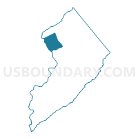
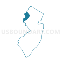
Knowlton township voting district 1, Warren County, New Jersey
About
Outline

Summary
| Unique Area Identifier | 622816 |
| Name | Knowlton township voting district 1 |
| County | Warren County |
| State | New Jersey |
| Area (square miles) | 15.02 |
| Land Area (square miles) | 14.70 |
| Water Area (square miles) | 0.32 |
| % of Land Area | 97.86 |
| % of Water Area | 2.14 |
| Latitude of the Internal Point | 40.95611860 |
| Longtitude of the Internal Point | -75.07668700 |
Maps

Graphs
Select a template below for downloading or customizing gragh for Knowlton township voting district 1, Warren County, New Jersey


Neighbors
Neighoring Voting District (by Name) Neighboring Voting District on the Map
- Blairstown township voting district 3, Warren County, NJ
- Blairstown township voting district 4, Warren County, NJ
- DELAWARE WATER GAP Voting District, Monroe County, PA
- Hardwick township voting district 1, Warren County, NJ
- Knowlton township voting district 2, Warren County, NJ
- PORTLAND Voting District, Northampton County, PA
- UPPER MT. BETHEL TWP VTD SLATEFORD, Northampton County, PA
- UPPER MT. BETHEL TWP VTD WILLIAMSBURG, Northampton County, PA
Top 10 Neighboring County Subdivision (by Population) Neighboring County Subdivision on the Map
- Upper Mount Bethel township, Northampton County, PA (6,706)
- Blairstown township, Warren County, NJ (5,967)
- Knowlton township, Warren County, NJ (3,055)
- Hardwick township, Warren County, NJ (1,696)
- Delaware Water Gap borough, Monroe County, PA (746)
- Portland borough, Northampton County, PA (519)
Top 10 Neighboring Place (by Population) Neighboring Place on the Map
- Delaware Water Gap borough, PA (746)
- Portland borough, PA (519)
- Columbia CDP, NJ (229)
- Hainesburg CDP, NJ (91)
Top 10 Neighboring Elementary School District (by Population) Neighboring Elementary School District on the Map
Top 10 Neighboring Secondary School District (by Population) Neighboring Secondary School District on the Map
Top 10 Neighboring Unified School District (by Population) Neighboring Unified School District on the Map
Top 10 Neighboring State Legislative District Lower Chamber (by Population) Neighboring State Legislative District Lower Chamber on the Map
- General Assembly District 23, NJ (229,972)
- State House District 189, PA (76,401)
- State House District 137, PA (72,979)
Top 10 Neighboring State Legislative District Upper Chamber (by Population) Neighboring State Legislative District Upper Chamber on the Map
Top 10 Neighboring 111th Congressional District (by Population) Neighboring 111th Congressional District on the Map
- Congressional District 15, PA (721,828)
- Congressional District 11, PA (687,860)
- Congressional District 5, NJ (666,551)
Top 10 Neighboring Census Tract (by Population) Neighboring Census Tract on the Map
- Census Tract 312, Warren County, NJ (7,949)
- Census Tract 311.01, Warren County, NJ (5,976)
- Census Tract 183, Northampton County, PA (4,859)
- Census Tract 182, Northampton County, PA (3,538)
- Census Tract 3005.01, Monroe County, PA (3,343)